Monday, June 10, 2013

13. The Underground Western Wall

Photo taken from the Western Wall Tunnel looking down into an excavated area. You can see how deep the wall is going down.
The upper two photos are from the Western wall Tunnels and the bottom two are from the men's prayer room inside the Wilson's Arch.The white structures are parts of the plastic chairs kept over the opening.

Photo: 3 July 2009 (Western Wall Tunnels) and 7 May 2010 (Wilson's Arch)

In its entirety Western Wall of Temple Mount has a length of 1600 feet, a height of 105 feet and built with 45 layers of stones from different periods. However, most of the original Western Wall is hidden behind residential structures built along its length. Today’s Western Wall or the ‘Ha Kotel Ha Ma’aravi’ is only 187 feet long, 62 feet tall and consisting of 28 courses of stones.  Not many are aware that a big share of Western Wall is hidden underground today. In fact, 43 feet of Western Wall made of 17 layers of stones from Herodian Period are concealed beneath the modern ground level. You can see this hidden segment of Western Wall from a few glassed openings inside men's prayer area behind Wilson's Arch and in the Western Wall Tunnels.


Location.
The Wilson’s Arch is on the left extreme end of the men’s section of the Western Wall, while visitor’s face the wall. In the prayer area inside Wilson’s Arch, look for the glass covered openings close to the Western Wall. You have to take the guided tour inside the Western Wall tunnels to see the other openings.

Sunday, June 9, 2013

12. The Small or Little Western Wall (Kotel Ha Katan)-1st Cent. BC

Look for the Hebrew sign in the upper photo; the lower photo is from the Sha'ar Ha Barzel Street
Entrance to the Small Western Wall

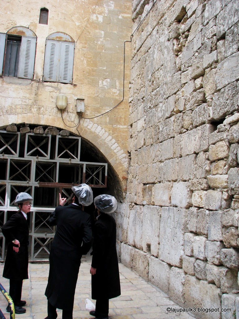
The tunneled passage to the small Western Wall


Remember that only the basal two layers (large stones) are from the Heodian Temple
Photos: 16 December, 2009.


The original Western Wall is about half a kilometer long (488 meters), but most of which serve today as walls of Arab residential buildings from the Mamluk and Ottoman era. The modern Western Wall (the Kotel) is only a 57 meters (187 feet) exposed section of this ancient wall from the Second Jerusalem Temple. However, few are aware of a ‘Small Western Wall’ (Kotel Ha-Katan), located just 200 meters north of the Kotel, inside the Muslim Quarter of the Old City of Jerusalem.

The Kotel Ha Katan is an exposed (i.e., with no houses covering it) segment of the Western Wall inside an Arab residential area of the Old City. Interestingly, the Kotel Ha-Katan is considered even holier than the Kotel since it is believed to be closer to the ‘Holy of Holies’ of Jerusalem Temple than any of the stones in the popular Western Wall. In fact, it is the second closest spot to the Holy of Holies (outside of the Temple Mount) where Jews can pray, the closest location is inside the Western Wall Tunnels. The Kotel Ha Katan is also much lower than the Kotel and lies on the same level as the Temple Mount itself. In Kotel Ha Katan, only the two lowest level of stones date from the Second Temple period, whereas in the main Kotel, there are seven rows from the same period. 

Despite being a site holier than the main Western Wall, the Kotel Ha Katan is visited by only a few worshipers, mainly because of its sensitive location inside the Muslim Quarter of Old City and its much smaller and narrower size (it is only 8 meters/25 feet long and 3 meters/10 feet wide) compared to the main Western Wall Plaza (57 meters/187 feet long and 38 meters/125 feet wide). Arab residents, who call it Rabat el-Kurd, use it as a passageway. For general tourists, the existence of such a wall is relatively unknown and a bit tricky to locate.

Location

To reach the Small Western Wall from the Western Wall Plaza, walk north (into the Muslim Quarter of the Old City) through the Rehov Ha Gai (El-Wad Street). Skip the first junction (you will see Suq al-Qattanin/Cotton Market Street, on your right and Hebron/Al-Halediya Street on your left) and keep walking in the El-Wad Street until you reach the Sha’ar Ha Barzel Street (Iron Gate Road) on your right. Go up to the end of this street which goes to the Bab el Hadid (Iron Gate), one of the entrances to the Temple Mount. Remember to take the narrow street to your left (Rabat el-Kurd) just before the Iron Gate. You should see an arrowed Hebrew sign in the turning saying L’Kotel Ha Katan (to the Small Western Wall), the way leads into the tunneled entrance to the Kotel Ha Katan. See the following map for a better picture. 
                                                                      Courtesy-Google Maps 

Friday, June 7, 2013

11. Judean Desert from Jerusalem.


 Judean Desert from Augusta Victoria Bell Tower

 Augusta Victoria Lutheran Evangelical Church of Ascension and its Bell Tower
Photos-25 August 2009

Judean Desert from Hebrew University Mount Scopus
Photo-11 December, 2009

Jerusalem is a city with several viewpoints; the most famous of them face west to the historic old city. However, Jerusalem is surrounded from the east by a dry desert, the Judean Desert which stretches up to the Dead Sea. I am told that if you are very lucky, it is possible to see the brilliant blue of the north of the Dead Sea from Jerusalem, provided you find a good viewpoint and more importantly a clear and bright sky. Dead Sea is approximately 35 km east to Jerusalem, but there is an altitude difference of 1200 meters. An ideal viewpoint to see the Judean Desert from Jerusalem is the bell tower of Augusta Victoria Church. Located at the summit of Mount Olives, the 50 meters tall bell tower gives an excellent view to the Judean desert, but there is the cost of climbing 223 sprightly steps! I wasn’t lucky to have a nice weather that day so you can see the photos are not clear. The Hebrew University campus in Mount Scopus is another choice, but the best spot I believe would be the 64 meters tall bell tower of the Russian Orthodox Church of Ascension in the Mount of Olives. Unfortunately, the bell tower is opened only once a year and I have not seen so far any pictures from the Russian Orthodox Bell Tower towards the Judean Desert.

Location

The bell tower is part of the ‘Augusta Victoria Lutheran Evangelical Church of Ascension’ (1910) located on the north side of Mount of Olives. The church is part of the Augusta Victoria Hospital located on Martin Buber Street. If you are using public transport, the best way is to get down at the hospital stop using Arab Bus No 75 from Damascus Gate.

Wednesday, June 5, 2013

10. Mamilla Cemetery (7th Century AD?)


The tomb of Kebekiyeh dia A-Din Aidughdi (d.1289), Governor of Safed.
Inside the tomb of Kebekiyeh dia A-Din Aidughdi
Photos taken on 29 January, 2010.

Mamilla Cemetery is one of the most prominent and ancient Muslim cemeteries in Jerusalem. According to Islamic traditions, the cemetery was active as early as 7th century and claims to be the burial site of the companions (Shahabah) of Prophet Muhammad. The name Mamilla is often ascribed as a contraction of Arabic term “M’amaan Allah” (under the protection of Allah) or “Man Min Allah” (coming from Allah). An alternate view is that Mamilla got its name from a Christian saint named St. Mamilla. There existed a church dedicated to St. Mamiila and a Christian cemetery on the site before Islam reached Jerusalem in 638 AD. The Church of St. Mamilla was active from the 4th to at least the 9th centuries. Historical records support Mamilla as an Islamic cemetery from the 11th century only. However, it is certain that from 11th century, aside from being a Christian cemetery for a brief period during the Crusader era, Mamilla remained without interruption as Muslim burial ground. The cemetery was perhaps the largest Islamic cemetery in Jerusalem until it became defunct in 1927. About 70,000 people are supposed to be buried in Mamilla cemetery through centuries. The total area of the cemetery has been estimated to range from 33 acres to 111 acres by various authorities. Among the buried notables were Islamic scholars, saints, emirs, muftis, Sufi mystics, 12th century soldiers of Saladin and Crusader soldiers.

Under Israeli control, the cemetery ground was used to make a public park (Independence Park, 1955), a parking lot (1964), a public lavatory, streets, squares and various Governmental buildings. The cemetery has become a site of much controversy after California based Simon Wiesenthal Center decided to build the 'Museum of Tolerance and Human Dignity' in 2004. The site selected for this purpose was a 3.5 acre plot near the cemetery where the parking lot was built in 1964. During the course of excavations on the site for construction, an estimated 1,000 skeletons were discovered, resulting in an intense public outcry against the museum by the Palestinian Arabs and many Israeli academicians and archaeologists. The work was halted several times only to be resumed after the Supreme Court of Israel rejected the Islamic Movement's petition in October 2008 and gave a final approval in July, 2011. The museum is expected to be completed by 2015 as against the earlier target of 2009. Vandalism to gravestones is being reported frequently from the Mamilla cemetery these days.

Palestinians consider the construction of the ‘Museum of Tolerance’ in Mamilla as an act of desecration, a defilement of Islamic holy site and an illegal acquirement of their ancestral burial ground used since the time of Prophet Muhammad. The Israeli supporters counter-argue that for 50 years, the site served as the municipality's car park where Muslims, Jews and Christians parked their cars there every day since the 1960s without any objection. They also cite incidents from 1929 and 1945 where Muslim leaders and Islamic councils gave permission to use the cemetery land for constructing hotels and business centers, an indication that the area is regarded as 'mundras,' or abandoned and without sanctity even before the modern state of Israel was formed.

More details can be availed in the Wikipedia link here for a general outlook on the subject. The Israeli viewpoints can be best summarized from an article written by Avra Shapiro here. The Palestinian concerns are nicely represented in a three part series of articles written by Rashid Khalidi here 1, 2 and 3. To get a better picture of the area, the following link to the map of the region would be much useful.

Location
Same as Mamilla Pool, see the post below.